Some of you have certainly heard about the conflict between Greece and Turkey in the Eastern Mediterranean.
But what is it about?
First things first, the biggest issue of dispute is about the Exclusive Economic Zone (EEZ) of the countries involved - Greece, Cyprus and Turkey.
The size/shape of this zone is defined be the United Nations Charter Law of the Sea (UNCLOS). This zone gives a country special rights regarding, for example, economic activity like fishing and energy.
In the following you see the EEZs of the Eastern Mediterranean as defined by UNCLOS.
Hier seht ihr die Zonen des östlichen Mittelmeers und wie sie von UNCLOS vorgesehen sind : pic.twitter.com/BNYIgNFCnw
— J-ex (@exj1925) September 18, 2020
Now some important facts that have to be taken into consideration:
1. Turkey does not recognize these zones and is not a signatory to UNCLOS.
2. The shown zones do not necessarily show the position of the respective government. Means there is room for negotiations.
Turkey has its own idea of how its EEZ should look like. This Idea is known as "Mavi Vatan" (Blue Homeland).
Nun hat die Türkei ihre eigenen Vorstellungen, wie ihre ausschließliche Wirtschaftszone auszusehen hat. Diese Vorstellung ist in der Türkei als Mavi Vatan (blaue Heimat) bekannt. Hier ein Bild. Diese Karte wird später nochmal bewertet. pic.twitter.com/u5NS0FM4Cz
— J-ex (@exj1925) September 18, 2020
The last years certain alliances have formed in the Eastern Mediterranean. One of them is the partnership between Greece, Cyprus and Israel. These countries want to build the East Med Pipeline. This pipeline will transport energy from Israeli gas fields to Greece via Cyprus and then to Italy.
This project is supported by the United States. Turkey is against this project.
Dieses Projekt wird von den USA unterstützt. Die Türkei ist gegen das Projekt. Hier eine Karte : pic.twitter.com/eQJp2u8xmm
— J-ex (@exj1925) September 18, 2020
Also there is the East Med Gas Forum. Participants are countries like Egypt, Greece, Israel, Cyprus, Jordan, Italy and Palestine. France and the US want an observer status.
Turkey is excluded. Reasons for this exclusion are according to Greece, Cyprus and Egypt, Turkeys illegal activities and their gunboat diplomacy.
An example for this illegal activity is Turkish research inside the EEZ of the Republic of Cyprus. Turkey justifies those activities through its illegal occupation of Northern Cyprus. To make it clear: The Turkish Republic of Northern Cyprus, which was created through Turkey's occupation, is not recognized by any country besides Turkey.
Zur Erinnerung, die durch die Besatzung geschaffene „türkische Republik Nordzypern“ wird von keinem Land anerkannt außer der Türkei. pic.twitter.com/BRX94o9nas
— J-ex (@exj1925) September 18, 2020
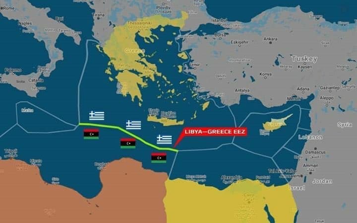
As a consequence of this isolation, Turkey went to one of its last allies in the region. The Prime Minister of the Muslim Brotherhood Government of National Accord (GNA) based in the Libyan capital of Triopoli, Fayez al Sarraj.
Turkey signed a Memorandum of Understand with the GNA. This MoU includes also an EEZ delimitation deal between Turkey and Libya. In return, Turkey supported the GNA against the Libyan Parliament and the Libyan National Army in the Libyan Civil War. Turkish support to the GNA include transport of jihadists from Syria to Libya, weapons and Turkish specialists for training.
Mit diesem hat er unter anderem einen Deal zur Abgrenzung der libyschen und türkischen ausschließlichen Wirtschaftszone unterzeichnet. Im Gegenzug, hat die 🇹🇷 Sarraj im Kampf gegen das libysche Parlament unterstützt. Unter anderem durch das Senden von Terroristen aus Syrien. pic.twitter.com/4APcSKbXpl
— J-ex (@exj1925) September 18, 2020
The legality of this deal was questioned in many countries. The scientific service of the German Bundestag wrote:
"In the Mediterranean, in the Aegean and in its Eastern part (between Turkey and Cyprus as well as the North African coast) it is nowhere more than 400 nautical miles wide, which basically means that EEZs of multiple countries collude, which requires an accurate delimitation, which is not always easy. However there is a principle in the Law of the Sea:
The delimitation between EEZs doesn't justify the rights of involved countries to an EEZ, but rather sets their existence as a precondition. There is already doubt about that regarding Turkey and Libya in the Mediterranean region southeast of Crete."
According to the Greek Government, islands are entitled to an EEZ. According to the Turkish Government, islands can be ignored. This is already implied by the Mavi Vatan Map.
Here an excerpt of the United Nations Convention on the Law of the Sea Article 121:
1. An island is a naturally formed area of land, surrounded by water, which is above water at high tide.
2. Except as provided for in paragraph 3, the territorial sea, the contiguous zone, the exclusive economic zone and the continental shelf of an island are determined in accordance with the provisions of this Convention applicable to other land territory.
3. Rocks which cannot sustain human habitation or economic life of their own shall have no exclusive economic zone or continental shelf.
The German Bundestag explains:
"According to Article 121 (2) of UNCLOS, it is clear that islands, regardless of their size, have the same sea areas (territorial waters, continental shelf and EEZ) as the mainland. The sea areas of islands have to be taken into consideration when delimiting EEZs."
Now people could argue that Turkey is not a signatory to UNCLOS and therefore this law is not binding for them.
Here the answer of the scientific service of the German Bundestag:
"A common law recognition of sea areas of islands has also a legal effect on countries which have not ratified UNCLOS."
"The economic concept of UNCLOS is indisputable a part of common law. The idea of a maritime zone of influence for the exploitation of resources surrounding territorial waters has already existed in the 19th century."
"As a consequence of the common law value of Article 121 (2) of UNCLOS, Turkey can not legally claim that it is not bound to UNCLOS which gives islands an EEZ because it has not ratified UNCLOS."
As a result the Bundestag writes:
"The maritimes delimitation of EEZs taking into account the sea areas of islands is in some cases difficult. But it is almost impossible, that an EEZ delimitation in the eastern Mediterranean which negates the sea areas of Greek islands - like the MoU between Turkey and Libya - is in accordance with the principle of equitable delimitation."
"Because the Turkish-Libyan MoU from the 27th of November 2017 negates the Greek EEZ southeast of Crete and gives Turkey an extended EEZ right in front of the coasts of Crete and Rhodes at the expense of Greece, it violates the common law recognized sea areas of Greek islands."
To come back to the Mavi Vatan map of Turkey: One can clearly see that this Map takes away rights from islands also in the Aegean.
Letzten Monat haben dann Ägypten und Griechenland ihre AWZ teilweise abgegrenzt. Auch hier eine Karte. Hier sieht man übrigens, dass es zwischen der UNCLOS Karte und dem geschlossenen Deal einen kleinen Unterschied gibt, wenn man genau hinschaut. pic.twitter.com/hoaodu0zja
— J-ex (@exj1925) September 18, 2020
Last month Greece and Egypt partly delimited their EEZ. It can be seen that there is a small difference between this map and the UNCLOS proposed map if you look closely.
That means that the UNCLOS map is not necessarily the position of government which has to be applied 100%. There is room for negotiations.
Another conflict between Greece and Turkey is about the territorial waters. According to the Law of the Sea, Greece is entitled to extend its territorial waters to 12 nautical miles (from the current 6nm). According to Turkey this would be a Casus Belli - a cause for war. The Turkish parliament already approved military action in such a case.
Here a map how it would change the geography of the region if Greece enacted its rights per international law.
Für die Türkei wäre dies laut Parlamentsbeschluss ein Casus Belli. Hier eine Karte wie sich die Geographie ändern würde. Sprich es gibt kaum noch internationale Gewässer und die Ägäis wäre de facto unter griechischer Kontrolle. pic.twitter.com/MBWSHiD0Oz
— J-ex (@exj1925) September 18, 2020
As a result there would almost be no international waters left and the Aegean would be de facto under Greek control.
Greece announced that it will extend its territorial waters in the Ionian Sea. So who knows what the future will bring for the Aegean.
Turkey wants to start its research inside the Greek EEZ in the near future again. Next week the EU will discuss possible sanctions against Turkey.
What can be said in conclusion is that islands clearly have an EEZ. How big this EEZ will be, is up for debate.
The views expressed by the author do not necessarily reflect those of Greek City Times.
