
The Greek city of Corinth of the Peloponnese has experienced a light tremor after an earthquake shook the area, measuring 4 points on the Richter scale on Sunday evening.
According to the Geodynamics Institute of Athens National Observatory the quake's epicentre was located 27 km northeast of Corinth and 53 km northwest of Athens.
Meanwhile, an earthquake measuring 5.2 on the Richter scale was recorded at 17:15 on Sunday in the sea region south of the island of Kassos.
According to the Geodynamics Institute of Athens National Observatory the quake's epicentre was located 46 km south of Kassos and 443 km southeast of Athens.
Prevously, the most recent recorded earthquake took place three weeks ago 19 kilometres west of the prefecture of Preveza.
The quake hit at a shallow depth of 10 km beneath the epicenter near Preveza, Préveza, Epirus, Greece, in the morning on Wednesday, December 8th, 2021, at 9:49 am local time.
RESOURCE | EARTHQUAKES IN GREECE
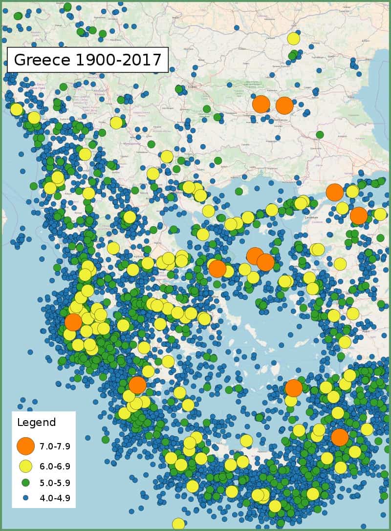
Greece is located at the complex boundary zone in the eastern Mediterranean between the African Plate and the Eurasian Plate. The northern part of Greece lies on the Eurasian Plate while the southern part lies on the Aegean Sea Plate. The Aegean Sea Plate is moving southwestward with respect to the Eurasian Plate at about 30 mm/yr while the African Plate is subducting northwards beneath the Aegean Sea Plate at a rate of about 40 mm/yr. The northern plate boundary is a relatively diffuse divergent boundary while the southern convergent boundary forms the Hellenic arc.
These two plate boundaries give rise to two contrasting tectonic styles, extension on east–west trending fault zones with strike-slip tectonics on SW-NE trending fault zones throughout west and central Greece, Peloponnese and the northern Aegean and contractional in the southern Aegean, continuing around to the Ionian islands. The south Aegean is the location of the volcanic arc and is characterised by extension. To the east of Crete along the Hellenic Arc, strike-slip tectonics with some extension become important.
The strongest earthquakes historically are those associated with the Hellenic Arc, although none larger than about 7.2 have been observed instrumentally. The events of AD 365 and 1303 are likely to have been much larger than this. In mainland Greece, normal faulting gives earthquakes up to 7 in magnitude, while in the northern Aegean, strike-slip events with a magnitude of 7.2 have been recorded. Large intermediate depth (>50 km) earthquakes of magnitude >7 from within the subducting African Plate have been recorded but such events cause little damage, although they are widely felt.
[Wiki]