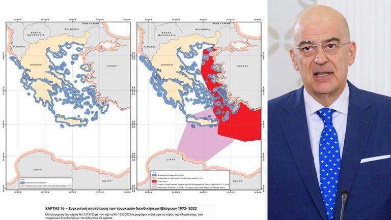
Athens on Thursday published 16 maps on its website that seek to demonstrate and explain the illegal and revisionist nature of the Turkish assertions and actions concerning the Greek islands, from 1973 until the present.
"In an effort to increase the wider public’s awareness of Turkish revisionism, the attached maps depict in a vivid and irrefutable way the Turkish illegal unilateral actions and claims," a foreign ministry announcement said.
As the announcement explained, the maps begin chronologically with the status quo enshrined in the Lausanne (1923) and Paris (1947) Treaties.
"Turkish claims are then presented, beginning with the illegal licensing of the Turkish state oil company (TPAO) for exploration of oil fields in areas of the Greek continental shelf in the North Aegean in 1973, and continuing with the attempt to usurp Greece’s responsibility for Search and Rescue services in half of the Aegean in the 1980s, the 'grey zone' theory in the 1990s, further escalation with the granting of new licenses in the Eastern Mediterranean, the endorsement of the 'Blue Homeland' as an official doctrine, the 'Turkish-Libyan Memorandum', reaching as far as the Turkish theory of the demilitarization status of the Aegean islands.
"The above-mentioned maps document the extent of Turkish revisionism in order to upend the status quo, violating International Law and the International Law of the Sea, and threatening peace, security and stability in our region," the ministry said.
All the maps can be viewed here.
With the maps it publishes, Athens is essentially exposing the Turks and their illegal claims in the Aegean, mobilizing the international community on the issues of demilitarization of the islands and the vision of the "Blue Homeland".
