The fire brigades are battling flames as they continue to burn Evros, northeast Greece.
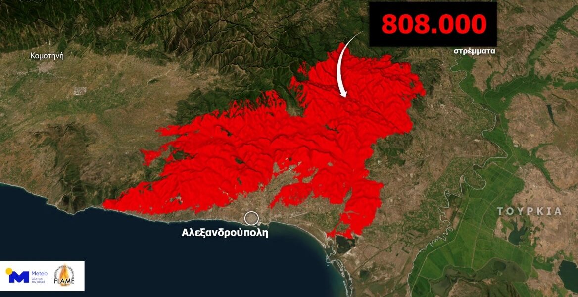
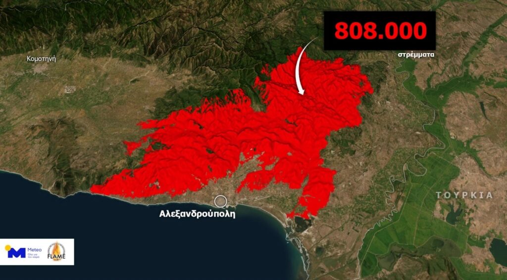
Newer satellite data was made available today by the Copernicus Rapid Mapping Service of the European Commission, which shows the devastation of the largest forest fire for many years on European soil.
According to the satellite data analysis, the total area burned by thEUe Evros forest fire, which resulted from the combination of the fires in Alexandroupolis and Dadia, exceeds 808,000 hectares (up to 28.08.2023, 12:28 local time).
#EMSR686 #Alexandroupolis #Greece🇬🇷
Our #RapidMappingTeam is working on its 6⃣th Delineation Monitoring Product for the historic #wildfire that is ravaging the East Macedonia & Thrace Region using VHR 🛰️ imagery
Updates 🔜 https://t.co/m030JiUPuq
👇"QuickLook" visualisation pic.twitter.com/i9z3rLfig6
— Copernicus EMS (@CopernicusEMS) August 28, 2023
The METEO unit of the National Observatory of Athens carried out the visualisation of the burned area.
See the burned area:
According to the Fire Department, extinguishing operations are concentrated in Lefkimmi, Leptokarya and Tris Vryses, where frequent flare-ups occur. Regarding the fire in Rodopi, there are flare-ups in the areas of Kassitera and Kirki.
In total, 475 firefighters with 100 vehicles and 16 teams on foot are operating on the fires in Evros and Rodopi, while six aeroplanes and four helicopters are assisting their efforts.
According to the Fire Department, scattered small outbreaks are observed on the southwest side of Mt Parnitha, while strong ground forces remain in the area for fear of rekindling. In particular, 260 firefighters with 77 vehicles and 13 teams on foot are operating in Parnitha, assisted by a helicopter.
Firefighters also struggle to put out flare-ups in Boeotia, specifically in Stiri and Kyriaki.
Meanwhile, Prime Minister Kyriakos Mitsotakis will chair a meeting on the restoration of the forests of Evros and Parnitha, with the participation of the Environment & Energy Ministry and the Climate Crisis & Civil Protection Ministry.
According to government sources, the meeting will occur at 11:00 at Maximos Mansion.
