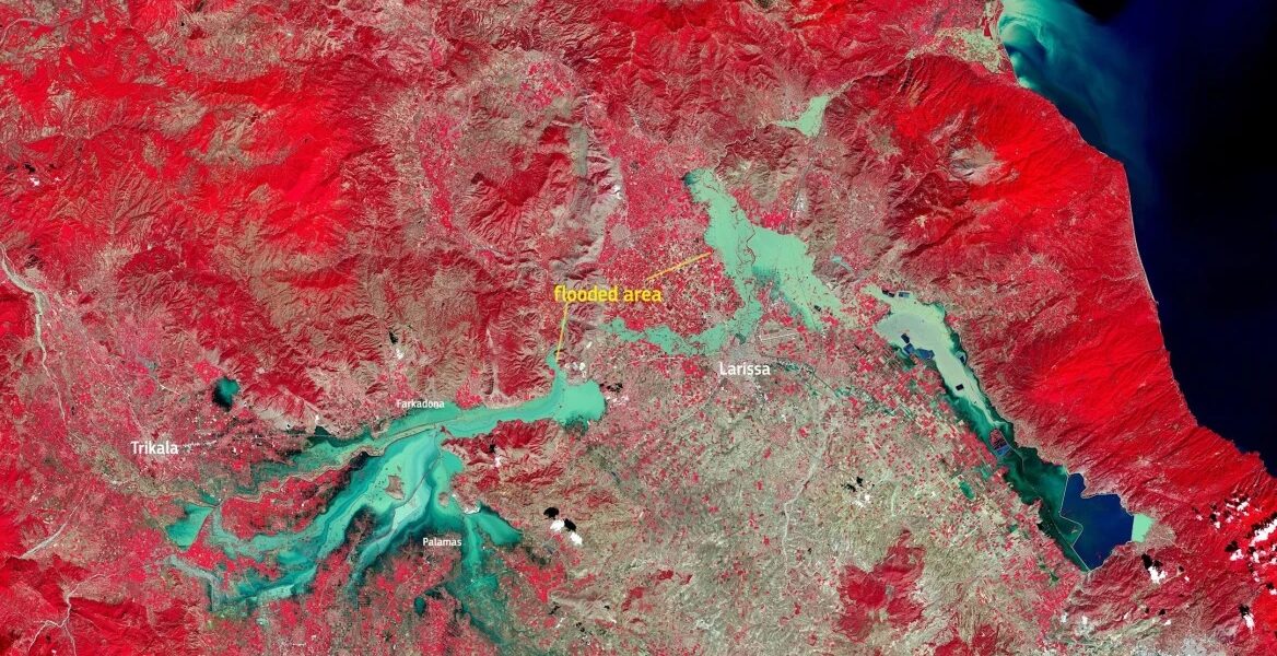
A new satellite image captures the devastation caused by the floods caused by the advance of storm Daniel in the areas of Thessaly.
As the European agency notes in its post, "On September 10, Sentinel 2 recorded this image from the area around Larissa, which is still heavily affected by the floods caused by the overflowing of the Pinios River."
Η #Ελλάδα αντιμετωπίζει εκτεταμένες #πλημμύρες
⬇️Στις 10 Σεπτεμβρίου, το #Sentinel2 κατέγραψε αυτή την εικόνα από την περιοχή γύρω από τη Λάρισα, η οποία εξακολουθεί να πλήττεται σε μεγάλο βαθμό από τις πλημμύρες που προκλήθηκαν από την υπερχείλιση του ποταμού Πηνειού pic.twitter.com/TXPgwTgquW
— Copernicus EU (@CopernicusEU) September 11, 2023
Government spokesperson Pavlos Marinakis, in a press briefing on Monday, said that "the security forces and military are continuing their efforts for the rescue and support operation in the areas hit by storm Daniel.
Marinakis noted that there have so far been more than 4,506 rescues and evacuations of citizens, who have been transferred to a safe place.
Of these, 774 were carried out using aerial means. "Humanitarian aid, water, medicines are sent to the flood-stricken either by boat or using drones and helicopters," he said, adding that transfers of the very elderly and people needing medical attention were continuing since the early hours of Monday.
He expressed his condolences to the victims' families, noting that 15 people had died and another two were missing.
The spokesperson underlined the need for all to follow the Health Ministry's instructions in managing the situation after the floods, pointing out that all the flood water is potentially contaminated as it may contain refuse that the floods or even dead animals have swept away.
READ MORE: Daniel storm: The waters reached 18 metres in Tempi Valley! The death toll reached 15.
