Turkey has no right to challenge the sovereignty of any island in the Aegean.
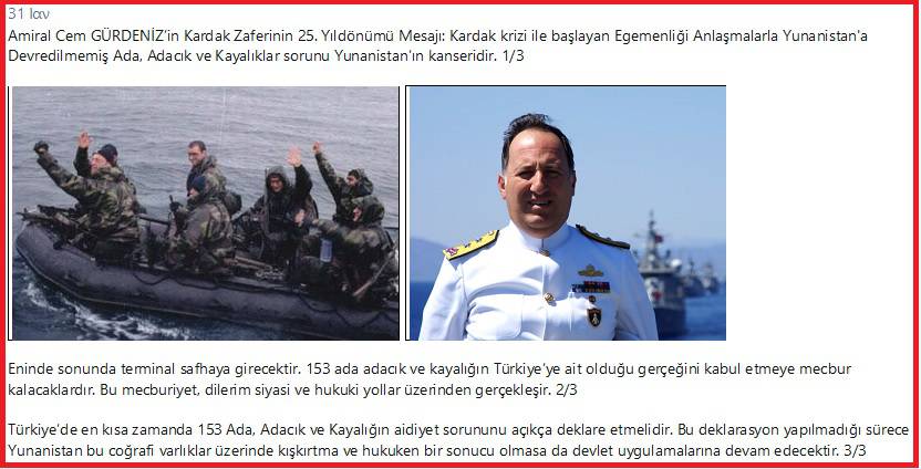
Recently, on the 25th anniversary of the Imia crisis, Cem Gürdeniz, a Turkish admiral, did not accept the dissolution of the Ottoman Empire and denied the consequences and the price of the wrong choices that his country made in World War I.
He literally stated that: "Imia was the beginning. There are 153 islands and islets whose status has not been clarified. Inevitably this issue will enter its final phase."
"Greece will eventually be forced to admit that they belong to Turkey. I hope this concession will be made through legal channels and bilateral agreements," he added.
Unfortunately, this view is shared by several other officials, strategic analysts and retired officers and politicians of our neighboring country.
You see from the little story they have, they do not want to see and digest that losers always pay while the winners benefit.
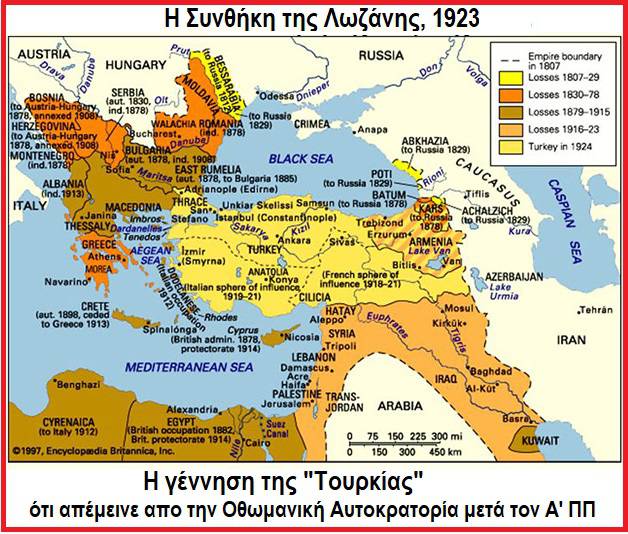
Turkey should have understood that their country was formed in 1923 and included what was left of the then fragmented Ottoman Empire.
New countries were created and new borders were drawn with the signing of the Treaty of Lausanne.
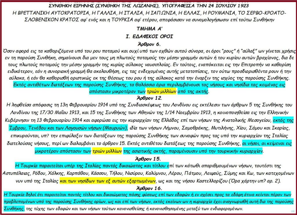
According to the Treaty of Lausanne that Turkey signed, it has sovereignty in the Aegean over Imvros, Tenedos, Lagouses and islands which are less than 2.6 nautical miles from the coasts of Asia Minor.
The other Aegean islands, according to Article 12, was given to Greece.
According to Article 16, "Turkey hereby renounces all rights and title" to the islands.
As for the Dodecanese, Turkey in Article 15 gave up all rights and titles in favor of Italy.
Let us remember at this point that, the Dodecanese during the Italian-Turkish War (1911-12) were occupied by the Italians and despite the signed peace pact, Turkey recognized Italian sovereignty in Libya.
Italy pledged to give the Dodecanese to Turkey, but this did not happen and so the islands remained under Italian occupation.
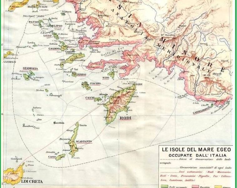
Dodecanese
After the signing of the Treaty of Lausanne in 1923, Italy officially annexed the Dodecanese on 6/8/1923 and the second period of Italian rule began.
The first governor was the Italian senator and plenipotentiary, Mario Lago.
On January 4, 1932, a deal was signed by the Italian Ambassador to Turkey, Baron Pompeo Aloisi, and the Minister of Foreign Affairs of Turkey, Dr. Tevfik Rüştü Bey.
It settled a dispute between Italy and Turkey over sovereignty over the islands off the coast of Anatolia and the island of Kastellorizo, as well as the islet of Kara Anta.
It also defined their territorial waters.
Shortly afterwards, on 28/12/1932, following the previous one, another agreement was signed between them, by which a committee of experts precisely defined, with 37 points, the Turkish-Italian border line.
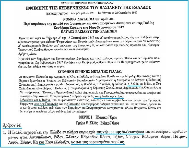
After the Second World War, these islands and with the current arrangements, passed from Italy to Greece on 10/2/1947, when the peace treaty between the allies and Italy was signed in Paris.
With this treaty, Italy ceded to Greece full sovereignty over the islands of the Dodecanese and the adjacent islets.
This treaty was ratified by Greece with legislative decree 423 on 22/10/1947.
It should be noted that in this treaty Turkey was not a party, again due to its choice of being friendly to Nazi Germany.
So I do not understand what they do not understand in Turkey and why they do not honour their signature.
Since the Treaty of Lausanne was signed unanimously at the time, since it did not have an expiration date and no one signed it with reservations, why does Gürdeniz and the conspirators, in his view, dispute it?
Hydrographic Service
Why don't they re-read articles 6, 12, 15 and 16 to confirm that, then, they relinquished all their rights over the islands.
Because they do not want to understand that with their obsession they not only freeze any progress in the region, but also threaten peace.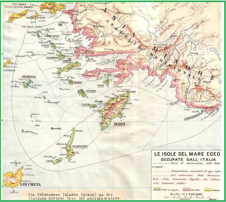
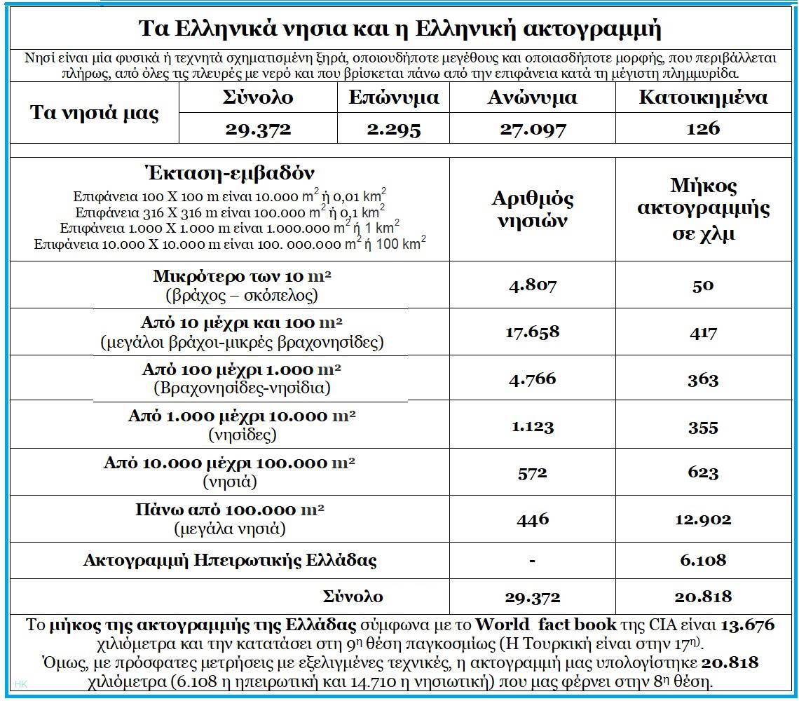
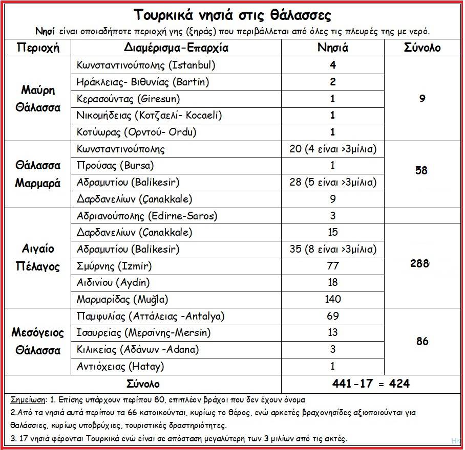
The Hydrographic Service (YY) of the Navy, from the beginning of our century, entered the digital world, while about ten years ago, with the acquisition of new devices, programs and methods, a new digital Cartographic Database was created.
This was necessary for the publication of digital maps.
In 2018, with the data of the Marine Geographic Information System (MARG), the Hydrographic Service tabulated the data resulting from the thematic level (Layer) of the coastline at a scale of 1:50,000, which are displayed in the relevant table.
Of course we must keep in mind that on the one hand, due to the geological changes that are constantly occurring (tectonic effects, rising water, etc.), and on the other hand due to the advancement of digital technology, the background is constantly being reviewed.
Island status
Now the background has improved and we have a scale of 1: 20,000. Therefore the data listed in the table may differ slightly in the future.
As for the Turkish islands, Turkey according to the Treaty of Lausanne, has 17 islands that it should not have since it is more than 2.6 nautical miles away from the coasts of Asia Minor.
In addition, in the Aegean, it has a coastal zone (territorial sea) of 6 nautical miles when it should have 2.6 nautical miles that the Treaty of Lausanne allows it to exercise.
Based on the signed treaty, the islets of
- Moschonissia opposite Lesvos,
- Adiavatos,
- Gialonisi,
- Daskaleio,
- Eleos or Leios,
- Kalamaki or Kalamopoulos,
- Kalamos,
- Olia,
- Pyrgos,
- and the islets of Lagouson-Mavrono,
- Mavrero,
- Mavreo,
- Mavrero,
and others which are not listed by name, must not be Turkish but Greek.
By the same token, the islands in the Sea of Marmara and the Propontis, which are more than 3 miles off the coast, must not be under Turkish rule.
These islands are: Prokonisos, Afisia, Kalolimnos, Koutali, Provatonisi.
This includes the Princes' Islands that are not mentioned by name in any treaty, as correctly pointed out by professor Angelos Syrigos.
A state that violates an international treaty cannot invoke a "violation" of a treaty by any other state.
A state that respects and honors its signature can only apply the Articles that interest it and cannot repeal or amend it, except by agreement of all the parties or by war.
Exploratory
Therefore, in order to stop any problems in the sensitive region of the Eastern Mediterranean and to deal with the progress and prosperity of our peoples, Turkey must sit at a table, just as it did in 1932 with Italy and Greece.
This is to define and delineate common borders based on the International Convention on the Law of the Sea.
Now, with the resumption of the Greek-Turkish talks, it is time at the 62nd meeting to define and delineate our borders, because only in this way will the frictions stop, the risk of a war conflict end, and the peoples, content with what they have, focus on prosperity.
To honor the first signing of an official document by the first Turkish state, Gürdeniz, leave the Blue Homeland idea and limit yourself to whatever islands you have without opening the bag of Aeolus that is of no use to anyone.
Iraklis Kalogerakis is a retired Rear Admiral and a regular contributor to SLPress.
