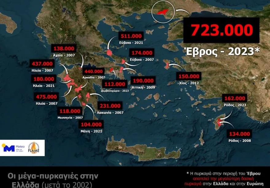
Newer satellite data by the Copernicus Rapid Mapping Service of the European Commission highlight the forest fire in Evros as the biggest forest fire in many years on European soil.
According to the satellite data analysis, the total area burned by the Evros forest fire, which resulted from the combination of the fires in Alexandroupoli and Dadia, exceeds 720,000 hectares (up to 23.08.2023, 12:19 local time).
METEO emphasises that by adopting the definition of a mega-fire as a fire that exceeds 100,000 acres in area, the FLAME pyrometeorological Team of the METEO unit of the National Observatory of Athens (EAA) presents on the map the mega-fires that hit Greece from in 2002 until 2023.
Sixteen mega-fires burned more than 4,200,000 hectares. Among them, the forest fire in Evros is now recognised as Greece’s largest mega-fire of the last 21 years.
Finally, it is essential to note that the most significant percentage of these mega-fires occurred in 2007-2009 (9 in total ), 1 in 2012 and 6 in 2021-2023.

Copernicus on fire in Alexandroupoli: “The largest burned area on European soil in years”
The European Copernicus service is recording the extent of the destruction that has taken place in the last few days in the broader area of Alexandroupoli through the Sentinel satellite.
According to what he claims in yesterday’s post, the area that had burned until Wednesday (23/8) in Alexandroupoli (over 72,000 hectares ) is the largest emergency CopernicusEU recorded on European soil for several years.
Copernicus related posts
#EMSR686 #Alexandroupolis #Greece
Our #RapidMappingTeam has delivered its
nd Monitoring Product for the large #wildfire burning in East Macedonia and Thrace Region
With a total burnt area of
,
ha
, this wildfire is the largest recorded on
European soil in years pic.twitter.com/qXdxAmsRuK
— Copernicus EMS (@CopernicusEMS) August 24, 2023
#ImageOfTheDay#Wildfires are devasting #Greece
Yesterday, #Sentinel2 captured the burnt scar around Alexandroupolis (which has reached
,
+ ha)@CopernicusEMS is working 24/7 to support those involved in tackling the ongoing
emergency
https://t.co/bCxJuDYHnA pic.twitter.com/nwFBYnxHqa
— Copernicus EU (@CopernicusEU) August 24, 2023
The Copernicus European service for the satellite recording of the burned areas and the damage caused by the great fire in Alexandroupoli was activated by the Planning and Emergency Management Directorate of the General Secretariat of Civil Protection last week following the General Secretary of Civil Protection order.
As stated in an announcement by the Ministry of Climate Crisis and Civil Protection, the purpose of the activation is the production of maps and data for areas of the Municipality of Alexandroupoli of the Regional Unit of Evros, which were affected by a fire that occurred on Saturday 19 August to assist the work of the agencies involved in dealing with emergencies and managing the consequences of the phenomenon.
READ MORE: Fire in Evros: “My sweet girls” – Beekeeper sobs goodbye to burnt bees.


